To generate electricity, humans rely on a variety of different technologies, ranging from burning coal to make steam, to combined-cycle natural gas turbines, to renewable resources like hydroelectricity and solar photovoltaics. Over time, the portfolio of energy resources upon which we rely may shift to less environmentally harmful assets.
For an example of how certain generation technologies may fall out of the generation mix, take the planned closing of the Salem Harbor Power Station. Located in Salem, Massachusetts (a city that sports solar photovoltaic-powered trash compactors on its sidewalks), this plant is one of several coal-fired power plants closing scheduled for the coming years. Since it started operations in 1951, the Salem Harbor Power Station has expanded and now generates 745 megawatts by burning coal and oil. Although the plant, currently owned by Dominion Resources, Inc. has increased its pollution control systems over the years, it was listed as one of the state’s “filthy five” dirtiest power plants in 2000, a hard reputation to shake. A study by Harvard University researchers at about the same time blamed the plant for 30 premature deaths annually, primarily due to air emissions.
Dominion, which purchased the plant in 2005, took steps to reduce emissions such as switching to lower the sulfur content of the coal burned there. However, the Salem plant has reportedly received $12 million in investments from Dominion since 2005—a marked contrast with the more than $1 billion Dominion invested into its 1,547 megawatt coal plant at Brayton Point in Somerset, Massachusetts.
As it is often the case, declining investments may result in the demise of production operations. Also, I have seen in similar context, the declining investments arise in part from declining economics that are to be seen at that facility. In the case of the Salem Harbor Power Station, the fact that Dominion could not shift the costs of new pollution controls to rate payers made further investment in the plant uneconomic. As a merchant generator in the ISO New England system, Dominion takes a market clearing price for its power, and thus cannot raise its rates over other resources to cover future increases in pollution control expenses.
The Salem Harbor Power Station is also a good example of how an increase in environmental regulation may lead to higher costs for certain kinds of generation units (in this case, coal-fired generation stations). Regulatory requirements to improve pollution control result in higher operational costs; these higher costs may in turn make even a relatively low fuel cost unit (such as coal) comparatively uneconomic. By comparison, once pollution controls are imposed on coal-burning units, the fact that renewable units such as wind or hydro or natural gas-fired units may not require such expensive pollution controls makes them relatively more economic.
Over time, it seems the balance has shifted, the generation mix will shift piece by piece as less economic units such as the Salem plant close, and new more economic units come online. Note that this does not always mean that the price of power goes down; rather, in this case, it is not that wind and hydro got cheaper, nor natural gas, but rather that the cost of coal now includes more expensive pollution control requirements, making it less economic. In 2009, coal fueled 12.8% of the New England portfolio; we shall soon see what 2010 has brought.
One other note on what happens if the Salem Harbor Station goes dark: ISO New England is now studying how to replace the plant, and true to its mission, is considering increasing transmission system upgrades in the region. This is an interesting example of how ISO New England focuses on transmission solutions — perfectly natural given its mandate — to replace a generation asset. While not all generation assets can be effectively replaced by transmission solutions, transmission between a remote generation resource and load may serve to replace at least some generation assets. Whether this will be correct in Salem remains to be seen. Within five years, the Salem station may be closed.

Energy powers society; society's choices shape energy policy. A blog about our energy resources and the choices they present for society.
November 29, 2010 - Cape Wind follow-up
Monday, November 29, 2010
In the wake of the Massachusetts DPU's approval of the Cape Wind contract with National Grid, interest in offshore wind technologies is growing. Under the deal, National Grid will buy half of Cape Wind’s output for a price that starts at 18.7 cents per kilowatt-hour, with a 3.5% annual escalator in each of the 15 contract years.
Today Motley Fool ran a piece noting potential winners from an increased belief that offshore wind is feasible and soon to be here. These winners include turbine manufacturers Vestas and Broadwind, as well as General Electric and Siemens. American Superconductor is pursuing technology to maximize the "power per tower" from offshore wind; its SeaTitan turbines are slated to produce more than 10 MW per turbine.
And don't forget my favorite search engine (though increasingly their business model relies on consumers seeing them as more than that): Google has already made the news for its involvement in energy markets. Now Google is investing in the underwater transmission lines needed to transmit power from offshore wind turbines to the mainland. Specifically, Google is eyeing a 350-mile line from Virginia to New Jersey, and may be interested in further projects to connect offshore generation to the onshore grid.
November 24, 2010 - Cape Wind approval order
Wednesday, November 24, 2010
Yesterday, I looked at the Massachusetts DPU's decision approving a 15-year power purchase agreement between Cape Wind and National Grid. Under the deal, National Grid will buy half of Cape Wind’s output for 18.7 cents per kilowatt-hour, with a 3.5% annual escalator in each of the 15 contract years.
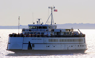 [Photo: the Martha's Vineyard ferry passes through Nantucket Sound, west of the Cape Wind site]
Right in the executive summary, the DPU presents its key finding: "that the Cape Wind contract is both cost-effective and in the public interest." As I read through the DPU's order, I was interested to see how the Department analyzed the facts to reach this finding. While the order resembles those approving contracts between utilities and more traditional generators, it diverged from these precedents in key ways including an analysis of how the contract would support the Commonwealth's renewable power standard and environmental goals.
For example, summarizing its analysis of cost-effectiveness, the DPU stated:
Another interesting section of the order was where the DPU found that this contract was cost-effective by comparison to other offshore wind projects. During the case, the Attorney General and Cape Wind each provided analyses comparing the costs and prices of the Cape Wind facility to a variety of operating and planned offshore wind projects here and abroad. Both the Attorney General and Cape Wind compared the power purchase agreement to that between Delmarva Power & Light Company and Bluewater Wind Delaware LLC for the output of its 200 MW offshore wind facility off Delaware. Analysis was also offered by the AG of the Deepwater Block Island LLC contract (28.8 MW proposed off Rhode Island) and (2) a un-named "domestic offshore wind project" whose information is protected by confidentiality.
After analysis, the DPU stated, "The various analyses performed by the Attorney General and Cape Wind demonstrate that the price terms of PPA-1 are reasonable compared to proposed offshore wind projects in the United States and to existing and proposed offshore wind projects abroad." The Order then compared Cape Wind's levelized price of $230 to the Bluewater levelized price of $230 and the Deepwater Block Island levelized price of $340.
Intuitively, that Deepwater came in with a higher price makes some sense. As the AG pointed out in the Cape Wind case, the nameplate capacity of the 28.8 MW project is just 6% of the capacity of Cape Wind's 468 MW, "presumably providing the Deepwater Block Island facility with fewer economies of scale".
If the Cape Wind order serves as precedent establishing the framework within which future renewable PPAs must fit, we have a lot to learn from the analysis in its 374 pages. Offshore wind developers and others interested in renewable projects who fit their projects into this framework may be better poised for regulatory approval.

Right in the executive summary, the DPU presents its key finding: "that the Cape Wind contract is both cost-effective and in the public interest." As I read through the DPU's order, I was interested to see how the Department analyzed the facts to reach this finding. While the order resembles those approving contracts between utilities and more traditional generators, it diverged from these precedents in key ways including an analysis of how the contract would support the Commonwealth's renewable power standard and environmental goals.
For example, summarizing its analysis of cost-effectiveness, the DPU stated:
As we have said, the price of the Cape Wind contract is $187 per MWh for 15 years, with a 3.5 percent annual escalator and opportunities for both upward and downward price adjustments depending on a variety of contingencies. Contrary to the assertions of some parties in the case, there are no additional transmission costs to customers beyond those that are already included in the contract price, and no costs of any significance to back up the addition to the regional electricity grid of an intermittent resource the size of Cape Wind.
On the other side of the ledger, the benefits associated with the Cape Wind contract include the value associated with the energy, capacity, and renewable energy credits that National Grid will purchase through the contract. In those years when the contract cost exceeds that value, National Grid customers will pay “above-market costs” for the Cape Wind contract. Based on the evidence presented, we believe the most likely range of above-market costs over the 15 years of the contract, including consideration of the price suppression effect, is from $420 million to $695 million.Thus the DPU asserts that over the life of the contract, National Grid's ratepayers will most likely pay $420 million to $695 million in above-market costs.
Another interesting section of the order was where the DPU found that this contract was cost-effective by comparison to other offshore wind projects. During the case, the Attorney General and Cape Wind each provided analyses comparing the costs and prices of the Cape Wind facility to a variety of operating and planned offshore wind projects here and abroad. Both the Attorney General and Cape Wind compared the power purchase agreement to that between Delmarva Power & Light Company and Bluewater Wind Delaware LLC for the output of its 200 MW offshore wind facility off Delaware. Analysis was also offered by the AG of the Deepwater Block Island LLC contract (28.8 MW proposed off Rhode Island) and (2) a un-named "domestic offshore wind project" whose information is protected by confidentiality.
After analysis, the DPU stated, "The various analyses performed by the Attorney General and Cape Wind demonstrate that the price terms of PPA-1 are reasonable compared to proposed offshore wind projects in the United States and to existing and proposed offshore wind projects abroad." The Order then compared Cape Wind's levelized price of $230 to the Bluewater levelized price of $230 and the Deepwater Block Island levelized price of $340.
Intuitively, that Deepwater came in with a higher price makes some sense. As the AG pointed out in the Cape Wind case, the nameplate capacity of the 28.8 MW project is just 6% of the capacity of Cape Wind's 468 MW, "presumably providing the Deepwater Block Island facility with fewer economies of scale".
If the Cape Wind order serves as precedent establishing the framework within which future renewable PPAs must fit, we have a lot to learn from the analysis in its 374 pages. Offshore wind developers and others interested in renewable projects who fit their projects into this framework may be better poised for regulatory approval.
November 23, 2010 - Cape Wind contract approved at 18.7 cents/kWh
Tuesday, November 23, 2010
Throughout 2010, I've been watching the Cape Wind project work its way through the development and regulatory processes. The project has generated controversy over a variety of issues, including siting (should the project be built in Nantucket Sound? if so, where?) and cost (should ratepayers be on the hook for a long-term power purchase agreement for the project's output? if so, at what price?). This latter issue falls under the jurisdiction of the Massachusetts Department of Public Utilities.
This week the DPU issued a decision approving a 15-year power purchase agreement between Cape Wind and National Grid. (The order itself is 374 pages.) Under the deal, National Grid will buy half of Cape Wind’s output for 18.7 cents per kilowatt-hour, with a 3.5% annual escalator in each of the 15 contract years. Some consumer advocates note that this is significantly higher than the most recent average annual wholesale power price in the region: 5.5 cents per kilowatt-hour. Proponents of the project point out that the 18.7 cent price includes the energy itself, capacity value, and renewable energy credits. A closer analysis of this suggests some flaws: the value of capacity plus renewable energy credits generally may not be worth the $132 per MWh price increase. Arguably the difference and that offshore wind has a social or intrinsic value that makes the price worth it.
The DPU acknowledged that the pricing is high:
If 18.7 cents seems high, it is among the lowest of the many of the recent proposed prices for offshore wind. It's worth noting that 18.7 cents per kWh is lower than the price set in previous proposed iterations of this contract. In May 2010, National Grid agreed to a deal at 20.7 cents per kWh (subject to DPU approval, which was withheld). The May proposal in turn was lower than the initial Deepwater Wind proposal off Rhode Island's Block Island, which proposed 24.4 cent per kWh power escalating 3.5% annually for 20 years to a final price of 48.6 cents per kWh. (And even that price was lower than the one Deepwater initially offered National Grid: 30.7 cents per kWh.)
The next step for Cape Wind is to look for a purchaser for the other half of its power. What kind of power purchase agreement will they find? If the DPU's approval of this contract establishes a pricing trend, we may see similar pricing in the second PPA.
This week the DPU issued a decision approving a 15-year power purchase agreement between Cape Wind and National Grid. (The order itself is 374 pages.) Under the deal, National Grid will buy half of Cape Wind’s output for 18.7 cents per kilowatt-hour, with a 3.5% annual escalator in each of the 15 contract years. Some consumer advocates note that this is significantly higher than the most recent average annual wholesale power price in the region: 5.5 cents per kilowatt-hour. Proponents of the project point out that the 18.7 cent price includes the energy itself, capacity value, and renewable energy credits. A closer analysis of this suggests some flaws: the value of capacity plus renewable energy credits generally may not be worth the $132 per MWh price increase. Arguably the difference and that offshore wind has a social or intrinsic value that makes the price worth it.
The DPU acknowledged that the pricing is high:
The power from this contract is expensive in light of today‖s energy prices. It may also be expensive in light of forecasted energy prices—although less so than its critics suggest. There are opportunities to purchase renewable energy less expensively. However, it is abundantly clear that the Cape Wind facility offers significant benefits that are not currently available from any other renewable resource. We find that these benefits outweigh the costs of the project.
One of the many benefits that Cape Wind provides is that it will assist National Grid and Massachusetts in meeting the renewable energy requirements of the Green Communities Act, as well as the greenhouse gas emissions reduction requirements of the Global Warming Solutions Act. Meeting those greenhouse gas emission mandates will require significant investments across all sectors of the economy, and especially from the electricity sector. We conclude that those requirements are unlikely to be met without the Cape Wind contract and the associated emissions reductions from the project.
If 18.7 cents seems high, it is among the lowest of the many of the recent proposed prices for offshore wind. It's worth noting that 18.7 cents per kWh is lower than the price set in previous proposed iterations of this contract. In May 2010, National Grid agreed to a deal at 20.7 cents per kWh (subject to DPU approval, which was withheld). The May proposal in turn was lower than the initial Deepwater Wind proposal off Rhode Island's Block Island, which proposed 24.4 cent per kWh power escalating 3.5% annually for 20 years to a final price of 48.6 cents per kWh. (And even that price was lower than the one Deepwater initially offered National Grid: 30.7 cents per kWh.)
The next step for Cape Wind is to look for a purchaser for the other half of its power. What kind of power purchase agreement will they find? If the DPU's approval of this contract establishes a pricing trend, we may see similar pricing in the second PPA.
November 23, 2010 - Twelve Mile Creek dam removal?
Whether a dam will be removed can depend on what's trapped behind it. Dams can trap a lot of sediment behind them, as solids carried downstream in a flowing river fall out into dams' impoundments as the flow backs up behind the dam. These sediments can add up to a huge volume of material. For example, on the Elwha River in Washington's Olympic Peninsula, where the Glines Canyon and Elwha dams are being removed, nearly 18 million cubic yards of sediment were trapped above the dams. That's a whole lot of sediment. (Picture a large gravel trailer passing you on the highway. Even if the truck can haul the weight, it's likely carrying less than 100 cubic yards, meaning it would take more than 180,000 truck trips to haul the sediment away.)
Sometimes the sediment trapped behind dams comes with an even heavier burden: toxic contaminants washed downriver from upstream sources. South Carolina's Twelve Mile Creek provides a vivid example of this hazard. From from 1955 to 1987, Sangamo Weston, Inc. owned and operated a capacitor manufacturing plant in Pickens, South Carolina. Waste and effluent including 400,000 pounds of polychlorinated biphenyls (PCBs) made its way (in part through direct discharges) to Town Creek and Twelve Mile Creek, a major tributary of the 56,000 acre Lake Hartwell (where Clemson, South Carolina is located). Sangamo Weston ultimately merged with Schlumberger. The area is now a Superfund site.
In 2006, a court ordered Schlumberger to take a variety of remedial actions, including paying $9 million in damages and removing two lower dams -- and possibly a third upstream dam owned by the Easley-Central Water District. It is this dam behind which some of PCB-laden sediments are now trapped. The question is not as much whether, but rather how much. Other sediments have made their way down into Lake Hartley; removal of the three dams is expected to allow cleaner sediments to flow down into Lake Hartwell where they are hoped to be able to cap the PCB-contaminated lake bottom. A study of this dam removal was approved earlier this year, but has yet to commence due to lack of funding.
If and when the dams in question are removed, what will happen to the sediment? Will it have downstream effects? PCB contamination can be serious, as seen in the Champlain Hudson Power Express transmission line's route jog to avoid PCB-contaminated sediments in the Hudson River. Recall that this PCB problem may have been exacerbated by dam removal: the 1970 removal of the Fort Edwards Dam on the Hudson River downstream of PCB-releasing General Electric factories allowed PCB-laden sediment to flow farther and more quickly downstream, resulting in one of the country's largest Superfund sites. By contrast, in Danville, Virginia, where the Brantley Dam is now targeted for removal, studies suggest a small enough volume of sediments (and a low enough toxics load) that dam removal may be feasible without requiring the kind of extensive sediment recovery that may be needed on Twelve Mile Creek.
November 22, 2010 - Champlain Hudson Power Express
Monday, November 22, 2010
A recurring theme this year is that Hydro-Quebec has a large amount of hydroelectricity that it would like to sell us. In order to sell Canadian hydro on the scale HQ envisions, as an engineering fact more transmission lines need to be built. Of these, what is now called the Northern Pass transmission project - effectively a high-voltage DC line capable of carrying 1,200 MW of steady imports into the US - has received a lot of attention. This imported power would be primarily generated by HQ's extensive network of hydroelectric facilities -- with an installed capacity and available supply of over 42,000 MW.
Another similar HQ-inspired transmission project is proposed just west of New England: the Champlain Hudson Power Express, a 300-320 kV DC line, consisting of two 5-inch cables to be buried at a depth of 3 feet. One unique aspect of this HVDC project is that it will be entirely underwater and underground, buried three feet into the substrate.
The proposed route interconnects with a proposed $400 million line project in Quebec. (The Canadian side will be developed by TransÉnergie, which is Hydro-Québec's transmission business.) The route runs from the Richelieu River in Quebec, south through Lake Champlain. Then, to avoid stirring up PCB-contaminated sediment in the Hudson River, the route leaves the water and runs under railroad right of ways. The line will be developed by a private developer (called Transmission Developers, Inc.) supported by the Blackstone Group. Users of the line (primarily utilities using the line to transmit power, or large industrial users who buy their own power) will pay for it. The line developer says its analyses show New York ratepayers will save $8.1 billion on their electricity bills between 2015 and 2024, by providing less expensive Canadian renewable power, which will force older and less economic domestic generating units offline.
Will these lines be built as proposed? What will their effects be on power prices in the U.S.? What effects will the imports have on the development of renewable generation in New England? The answers to these questions remain to be seen. With its large surplus of generation over domestic load, we can be sure that Hydro-Quebec will remain open to selling us power for the foreseeable future -- but the cost of that power, in both cents per kilowatt-hour and in terms of societal impacts, may be hard to calculate.
November 17, 2010 - Boon Island offshore wind test site
Wednesday, November 17, 2010
In recent entries, I've been looking at potential development of Maine's offshore wind energy resources. For example, this week I've looked at the test wind site off Monhegan Island, to be developed by the DeepCWind Consortium. Back in August, I sailed past Damariscove Island, another of the three offshore wind test sites approved by Maine.
 [Photo: Damariscove Island, one of Maine's offshore wind energy test sites.]
Maine's third offshore wind test site will be the waters off Boon Island near York. (Boon Island is also the site of the shipwreck of the British freighter Empire Knight, whose sunken remains may contain over 8 tons of mercury, and possibly $200 million in copper-platinum wire.)
Boon Island is about 6 miles offshore of York. It's a notorious shipwreck site, and has been home to navigational aids for over 200 years. The current incarnation, Boon Island Light, is the tallest lighthouse in both Maine and New England at 133 feet in height; people on shore, as well as those at sea, can see its white beacon flash every 5 seconds. Boon Island Light and its predecessors have faced some powerful storms over the years, some of which have been damaging.
Back in December 2009, the waters off Boon Island were selected as an offshore wind energy test site. Unlike the Monhegan site, which will be developed by the DeepCWind consortium, the Boon Island offshore wind site is available for a commercial developer to build a test facility. As Maine's development of its offshore energy potential progresses, who will apply for the site license for Boon Island?
November 16, 2010 - DeepCWind off Monhegan
Tuesday, November 16, 2010
Yesterday I looked at the DeepCWind consortium's plan to develop an offshore wind test site in the waters south of the island of Monhegan, Maine.
 [Photo: Manana Island, seen from the approach to Monhegan.]
In the next years, members of the consortium will continue to collaborate as they work on testing both the offshore energy potential for Monhegan wind, as well as the technologies needed to harvest and transmit that offshore wind energy to serve load.

The members of the DeepCWind consortium are arranged into 8 function-oriented task groups. These tasks are:
- Task 1: Micrositing, Geophysical Investigations, and Geotechnical Engineering
- Task 2: Study of Environmental/Ecological Impacts
- Task 3: Permitting and Policy
- Task 4: Floating Turbine Design, Material Selection, and Lab Testing
- Task 5: Offshore Turbine Testing, Monitoring, and Reliability
- Task 6: Education and Outreach
- Task 7: Project Management and Reporting
- Task 8: Fabrication and Deployment
- AEWC Advanced Structures and Composites Center
- Cianbro Corporation
- General Dynamics Bath Iron Works
- Maine Maritime Academy
- Bangor Hydro Electric Company
- Central Maine Power Company
- Technip USA
- Reed and Reed
In the next years, members of the consortium will continue to collaborate as they work on testing both the offshore energy potential for Monhegan wind, as well as the technologies needed to harvest and transmit that offshore wind energy to serve load.
November 15, 2010 - Monhegan energy: wind?
Monday, November 15, 2010

Maine has designated the waters offshore of Monhegan Island as a test site for offshore wind energy development.
[Photo: down by the dock, Monhegan Island, Maine.]
The DeepCWind Consortium is planning to develop a one-third scale test platform and turbine about two miles south of Monhegan Island. Exactly what type of platform will be tested is still up in the air, but choices under consideration include single spar, tension leg, and buoyancy stabilized designs.
Who is DeepCWind? It's a consortium composed of a mix of private businesses and academics. DeepCWind has been successful at grant writing and fundraising; for example, the US Department of Energy has awarded the consortium an $8 million grant to support its research.
The Monhegan site was announced by Governor Baldacci last December as one of three offshore wind test sites. The Monhegan energy site will be developed by DeepCWind, while two other sites - one near York, Maine's Boon Island, and one off Damariscove Island near Boothbay - will be developed by private companies. Each site measures between 1 and 2 square miles, and all fall within in Maine’s territorial waters. The upshot of this is that Maine, not the federal government, will have authority to regulate siting issues.
If DeepCWind succeeds, within two years, we'll see an offshore wind energy test site in the waters south of Monhegan.
November 11, 2010 - Veterans Day, and US military energy
Thursday, November 11, 2010
Happy Veterans Day. In honor of the day, let's peek at what the US military is doing on one energy issue: preparing for changes in fuel availability.
 [Photo: a reminder of summer, Monhegan Island, Maine.]
Did you know that this year, the US Navy successfully completed tests in Norfolk on a 49 foot-long riverine command boat powered by a 50/50 mix of diesel and algae-derived biodiesel? In the wake of this spring's Joint Operating Environment report noting possible future scarcity of oil (as in "peak oil"), the military is predicting that it may need to have assets that can run on a variety of fuels. This spring's report predicted the possibility that the the world's surplus oil production capacity might be sucked up within two years, resulting in a potential excess demand of nearly 10,000,000 barrels a day within the next five years. In addition to ships, the Navy's interest in adding flexible fuel capacity has also led to biofuels and coal-derived synthetic fuels to power jet engines as well.
Military applications add a national security aspect onto the basic arguments in favor of biofuels as part of a fuel portfolio. While initial algae-derived biofuels delivered to the military were relatively expensive (reportedly $424 per gallon), the price has already fallen significantly as production capacity responds to the increased demand. Will the predictions in the Joint Operating Environment report come true? If so, being able to run on a variety of more cost-effective fuels including biofuels may prove invaluable.
November 10, 2010 - dam removal on Martha's Vineyard
Wednesday, November 10, 2010
This summer I was fortunate to spend a week on the island of Martha's Vineyard in Massachusetts. I learned about the island's energy resources, including solar and wind on Martha's Vineyard.
Following up on my recent looks at dam removal, today I'm looking at some possible dam removal activity on Martha's Vineyard. It's what you might term a large-sized island: 87.48 square miles (231.75 km²), making it the third-largest island on the east coast of the US, and the largest island on the east coast not tied to land by a bridge or tunnel. Population-wise, the year-round population of about 15,000 residents is augmented by tourists and seasonal residents, peaking at up to 75,000 people in summer. Still, it's a manageable size, with all points of the island relatively accessible to visitors.
It's the relatively moderate size of Martha's Vineyard that made me surprised to learn that the island is home to at least 3,000 dams. That's about 13 dams per square kilometer, or 34 dams per square mile. The vast majority of these dams were built in the last 200 years to provide power, water, or both to mills -- almost all of which are no longer in operation. With no maintenance, and no ongoing operations like hydropower production, many of these dams have become overgrown, forgotten, and in poor condition.
In response to a near-disaster in 2005 when rain-induced flooding nearly broke an old dam in a densely-populated area, the Commonwealth of Massachusetts enacted new dam safety and liability laws. These changes made it more clear that whoever owns a dam is responsible for its safety -- and for the consequences of its failure. Many property owners did not even realize that they owned aging dams when they purchased former industrial sites, like the Briggsville Dam in Clarksburg whose owner was surprised to find itself responsible for costly repairs or removal.
When costly repairs are required to maintain state and federal licenses and certifications, dam removal is one option. Some dams on the Vineyard still provide valuable services, like flood control or providing water supply to residents and businesses. Others, like the Mill Pond dam in West Tisbury, impound water for scenic and recreational purposes. Still others remain in streams, holding back small ponds, in unknown condition. Some may be candidates for removal, while others may be candidates for powering up as small hydro-electric sites. As an island interested in sustainability, as well as reliability, it will be interesting to see which Martha's Vineyard dams are removed, and which will be restored.
 |
| Photo: wind power near the islands: Falmouth, Massachusetts. |
Following up on my recent looks at dam removal, today I'm looking at some possible dam removal activity on Martha's Vineyard. It's what you might term a large-sized island: 87.48 square miles (231.75 km²), making it the third-largest island on the east coast of the US, and the largest island on the east coast not tied to land by a bridge or tunnel. Population-wise, the year-round population of about 15,000 residents is augmented by tourists and seasonal residents, peaking at up to 75,000 people in summer. Still, it's a manageable size, with all points of the island relatively accessible to visitors.
It's the relatively moderate size of Martha's Vineyard that made me surprised to learn that the island is home to at least 3,000 dams. That's about 13 dams per square kilometer, or 34 dams per square mile. The vast majority of these dams were built in the last 200 years to provide power, water, or both to mills -- almost all of which are no longer in operation. With no maintenance, and no ongoing operations like hydropower production, many of these dams have become overgrown, forgotten, and in poor condition.
In response to a near-disaster in 2005 when rain-induced flooding nearly broke an old dam in a densely-populated area, the Commonwealth of Massachusetts enacted new dam safety and liability laws. These changes made it more clear that whoever owns a dam is responsible for its safety -- and for the consequences of its failure. Many property owners did not even realize that they owned aging dams when they purchased former industrial sites, like the Briggsville Dam in Clarksburg whose owner was surprised to find itself responsible for costly repairs or removal.
When costly repairs are required to maintain state and federal licenses and certifications, dam removal is one option. Some dams on the Vineyard still provide valuable services, like flood control or providing water supply to residents and businesses. Others, like the Mill Pond dam in West Tisbury, impound water for scenic and recreational purposes. Still others remain in streams, holding back small ponds, in unknown condition. Some may be candidates for removal, while others may be candidates for powering up as small hydro-electric sites. As an island interested in sustainability, as well as reliability, it will be interesting to see which Martha's Vineyard dams are removed, and which will be restored.
November 9, 2010 - removal of the Brantley Dam, Virginia?
Tuesday, November 9, 2010

Today I'd like to comment on the story of the Brantley Dam on the Dan River in Danville, Virginia (about 4 hours west of Norfolk). This older dam once provided water to the now-closed Brantley Steam Plant. Over the years of changing ownership and possibly insufficient maintenance, the dam has recently become unpopular. Dam safety is a major issue, with 4 deaths since 1965 attributed to the dam.
The City of Danville Public Works department has issued a report recommending that the Brantley Dam be removed. The City is now considering removing the dam, and whether sediments trapped in the impoundment behind the dam may be toxic or polluted. The report suggests a variety of costs for dam removal, ranging from $90,000 for a "simple removal", $110,000 for a “staged removal" - or about $307,000 to remove the dam along with the entirety of the trapped sediments. Based on the relatively low amount of sediments, the report suggests simple removal is appropriate.
I'm curious to see what will happen with dam removal on the Dan River. A number of other dams exist across the watershed, some of which are privately owned, and at least one of which (at a water treatment plant) is a partially breached low-head dam - picture a 30' breach in the middle of a short, curving structure.
In this case, the dam played a role in energy generation, though not through hydroelectric capacity; rather, like the Briggsville Dam in Clarksburg, Massachusetts, it was built to provide a steady supply of water for industrial processes. In this case, the Brantley Dam supplied water to the steam plant electric generation station. As the economy of industrial production has shifted over the past century, the underlying factory or power plant may change its operations, leaving the dam without its original purpose. In Brantley Dam's case, the steam plant was ultimately shut down by the utility.
At some point, if the dam poses harms identified by society (safety at the Brantley Dam) without commensurate benefits, the dominant pressures may result in dam removal. In other cases, especially where hydroelectric production is possible, if dam removal is threatened absent improved fish passage, developers may find it worthwhile to maintain the dam in compliance with the regulations. In either case, it's a balancing act.
In Maine, last month I noted that the towns of Canton and Hartford were looking for ways to fund a dam repair project on Whitney Brook. This dam maintains the water levels in Lake Anasagunticook. The state had condemned the original dam, and the temporary dam needed repairs. In today's news, the towns have announced that the Maine Outdoor Heritage Fund has awarded them a $5,000 grant for the project. This fund is funded by designated lottery tickets, and can be used to acquire land and secure public access. One portion of the project includes a new boat launch and park, triggering eligibility for this grant.
November 8, 2010 - NECBC U.S.‐Canada Energy Trade and Technology Conference recap
Monday, November 8, 2010

I enjoyed the 18th Annual U.S.‐Canada Energy Trade and Technology Conference sponsored by the New England - Canada Business Council last Thursday and Friday. I've been a regular attendee in recent years, and this year's program was as dynamic as any I've seen. On Thursday afternoon, my colleague Steve Hudson moderated a roundtable discussion on Washington and Ottawa Energy and Environmental Policy Initiatives. Friday, participants enjoyed a mix of high-impact speakers like Nova Scotia Premier Darrell Dexter and lively panels with key executives in regional energy businesses like Hydro-Quebec, TransCanada Power, and Tennessee Gas Pipeline. The noontime panel held conference attendees rapt with a spirited discussion of some of the aspects of the Cape Wind offshore wind energy project and contracts for sale of its renewable power. The sessions culminated with a keynote address on federal energy policy by a speaker from the US Chamber of Commerce.
It was very interesting learning from the speakers about their perspectives on energy issues. To me, it was even better to reconnect with friends and get to know fellow conference attendees. Hope to see you at the 19th annual NECBC energy meeting next year.
November 5, 2010 - NECBC's energy conference
Friday, November 5, 2010
Today I am at the New England Canada Business Council (NECBC)’s 18th Annual Energy Trade & Technology Conference is underway, on Nov. 4-5, 2010 at the Seaport Hotel, Boston. This is always a great event focusing on energy trade between the Northeast U.S. and Canada, our largest energy supplier. Last night we had a roundtable discussion on the implications of the recent election. This morning, I'm looking forward to a keynote speech by the Hon. Darrell Dexter, Premier of Nova Scotia, as well as the panel discussions featuring senior executives from companies like Hydro-Quebec Production,Northeast Utilities, Nalcor Energy, Cape Wind, and Repsol.
November 4, 2010 - what kinds of generation make up Maine's standard offer mix?
Thursday, November 4, 2010
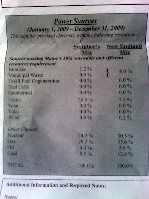
The photo above shows a recent mailing I received at my house detailing the power source mix for the current standard offer provider for customers of Central Maine Power's T&D network: NextEra Energy Power Marketing, LLC.
You can see that the largest share of power sourced by NextEra in 2009 was hydro (30.9%), with gas a close second (29.2%) and nuclear power (basically, Seabrook) at 24.5%. In total, 33.5% of NextEra's energy supply came from sources meeting Maine's renewable portfolio standard requirements. By contrast, the average New England mix is more heavily weighted in gas, nuclear, and coal, with renewable sources playing a much smaller role.
The generation mix is not simply an academic question; it has implications for other policy choices. For example, we've seen in past entries how the generation mix can affect other environmental claims, like what kind of emissions are associated with electric vehicles.
Interestingly, the supply mix is slightly different from the last time I got a notice.
November 3, 2010 - New Hampshire dam removal
Wednesday, November 3, 2010
Dam removal activities are ongoing across the country, and New Hampshire dam removals are among them. Continuing my survey of dams being removed: today, a look at recent and potential future dam removal activity in New Hampshire. (If you're looking for Maine dam removal information, check out my post here.)
 Photo: a half-forgotten cemetery hidden in the woods just off the beaten track.

According to the New Hampshire Department of Environmental Services, the following New Hampshire rivers have seen dams removed in the last decade:
- Ashuelot River, McGoldrick Dam, Hinsdale (Removed, 2001)
- Ashuelot River, Winchester Dam, Winchester (Removed, 2002)
- Bearcamp River, Bearcamp River Dam, South Tamworth (Removed, 2003)
- Bellamy River, Bellamy River Dam #5, Dover (Removed, 2004)
- Contoocook River, West Henniker Dam, Henniker (Removed, 2004)
- Tioga River, Badger Pond Dam, Belmont (Breached, 2004)
- Champlin Pond Dam and Champlin Farm Pond Dam, Rochester (Removed, 2005)
- Pearl Lake Brook, Pearl Lake Brook Dam, Lisbon (Removed 2007)
- Souhegan River, Merrimack Village Dam, Merrimack (Removed 2008)
- Black Brook, Maxwell Pond Dam, Manchester (Removed 2009)
- Winnicut River, Winnicut River Dam, Greenland (Removed 2009)
- Ashuelot River, Homestead Woolen Mill Dam, West Swanzey
November 2, 2010 - Veazie dam removal
Tuesday, November 2, 2010
Yesterday, I looked at the Great Works Dam on the Penobscot River, and the plans to remove it. Today, let's consider the history and fate of its sister the Veazie Dam - another dam linked by the Penobscot River Restoration Project to ultimate removal.
 Photo: fall foliage near the mouth of the Kennebec River, Maine.
The Veazie Project is the lowermost project on the entire Penobscot River system. It consists of a 902-foot-long, 25-foot-high, concrete gravity dam with inflatable rubber flashboards, a reservoir with a surface area of about 390 acres and a storage capacity of 4,800 acrefeet at a surface elevation of 34.8 feet mean-sea-level (msl), and two powerhouses on the Veazie (west) side of the river (Plant A with an installed capacity of 5.4 MW and Plant B with an installed capacity of 3 MW). A forebay located on the right side of the river feeds both powerhouses. The tailrace of Plant A is located under the concrete floor of the forebay and Plant B releases water into the river downstream of the dam. The project also includes two fish ladders: an abandoned fishway on the left bank of the river, and an operable ladder between the spillway and forebay.
As part of the comprehensive basin-wide settlement agreement between environmental advocacy organizations, state and federal agencies, and the dam owners on the Penobscot River system, the Veazie Dam is slated for removal. The Penobscot River Restoration Trust has won approval from the Federal Energy Regulatory Commission to initiate the demolition of the Veazie dam by drawing down the impoundment through the project’s gates and by deflating the flashboards. Next, access roads would be constructed on the east bank of the Penobscot, both upstream and downstream of the dam to facilitate the demolition of the abandoned fish ladder and the east half of the spillway. Once these easterly roads are removed, the remaining portion of the spillway, powerhouse B, the operational fish ladder, the forebay, and tailrace would be removed by a west bank access road.
As the impoundments behind newly constructed dams fill with water, they often cover rivers' previous history. Approximately 1,900 feet upstream of the Veazie Project are the submerged remnants of the historic Veazie Lumber Company Mill dam. Because this structure is expected to significantly impair natural river flow once the Veazie dam is removed, this historic remnant is also slated for removal once the Veazie Dam is gone.
All this arises through the Lower Penobscot River Basin Comprehensive Settlement Accord. As FERC describes it, the Settlement Accord will open a large amount of habitat to anadromous fish in the Penobscot Basin by removing the Veazie and Great Works dams and constructing a bypass around the Howland dam while retaining up to 90% of the then existing hydroelectric generating capacity within the Penobscot River area.
November 1, 2010 - Great Works dam removal?
Monday, November 1, 2010

Brilliant fall colors in the Basin, Phippsburg, Maine.
Continuing my look at dams targeted for removal: today, the Great Works dam on the Penobscot River in Maine. This is an interesting tale of mills, dams, changes in ownership, and changes in use. Like the Briggsville Dam in Clarksburg, Massachusetts, the Great Works dam was built to support a mill -- but like the Boston Felt dam, the Great Works dam produced renewable power.
The Great Works Hydroelectric Project (FERC project no. 2312) is located adjacent to the Old Town mill (which has changed hands over the years, and is now owned by Old Town Fuel and Fiber). Originally built in the late 1800s, the Great Works project's FERC license was issued in 1963, with an original expiration date of March 31, 2002.
In its most recent incarnation, Great Works consisted of a powerhouse containing 11 turbine-generator units totaling about 8 MW of installed capacity; a non-overflow section with two operating fishways and three gated outlet pipes (one 6 foot square, two 9 foot diameter); and a spillway equipped with flashboards extending from the non-overflow section across the river to the east river bank in the Town of Bradley. The total length of the Project is approximately 1,353 feet. The dam forms a 128-acre impoundment at a normal impoundment elevation of 81.73 feet. The tailrace is separated from the main river by an earthen dike and the powerhouse discharges to the tailrace. The presence of the earthen dike creates a bypass reach of approximately 1,200 feet in length, and approximately 1,000 feet of which is a backwater. The project also includes two operating Denil-type fish ladders, one located in the tailrace, the other at the west end of the spillway. An older abandoned fish ladder is located near the center of the spillway.
In March 1997, James River Paper Company owned both the mill and the dam. James River filed a notice of intent to file an application for a new license. Shortly thereafter, the dam changed hands to PPL Great Works, LLC. In 2003, Commission staff suspended the processing of the project's relicense application to allow negotiation of a multi-project, "basin-wide settlement agreement" - a comprehensive agreement covering water flows and dams throughout the Penobscot River watershed.
That agreement - the Lower Penobscot Basin Comprehensive Settlement Accord - ensued on June 25, 2004. Seven conservation groups, hydroelectric company PPL Corp., the Penobscot Indian Nation and state and federal agencies, agreed to the removal of both the Great Works and Milford dams as well as the removal of flashboards and the installation of a fish bypass at the Howland Dam.
Pursuant to the settlement agreement, on November 7, 2008, PPL Great Works and the Penobscot River Restoration Trust (Trust) filed an application to transfer the license to the Trust, and the Trust filed an application to surrender the license for the Great Works Project and remove the project’s dam.
On June 16, 2010, FERC issued its order approving the surrender of the project license (29 page PDF of the order). In its order, FERC described the process to be used in removing the Great Works dam:
The Great Works Project impoundment would be drawn down through the opening of gates and removal of the flashboards. Then, an upstream access road would be constructed from the east bank along the entire length of the spillway. Another road would be constructed downstream out to mid-channel to allow removal of the abandoned fish ladder. The spillway would be removed in sections from west to east with concurrent removal of the access road. Following this, another road would be constructed from the west bank across the upstream side of the powerhouse. From this road, the remaining portion of the spillway immediately adjacent to the powerhouse would be removed along with the two operational fish ladders. The forebay area would be filled and graded and the access road removed. The project’s powerhouse is proposed to remain because it houses equipment for an adjacent pulp mill.Removal of the Great Works dam may occur in 2012, bringing a close (or at least a new chapter) to this tale of a mill and its dam. In this case, the greater Lower Penobscot Basin Comprehensive Settlement Accord and the actions of the Penobscot River Restoration Trust played a major role. In a coming edition, I'll look at the policy considerations that went into that settlement agreement, including the promises of both improved sea-run fish passage and continued hydroelectric generation elsewhere on the Penobscot River.
Subscribe to:
Posts (Atom)