Showing posts with label history. Show all posts

Tide Mill Institute 2015 conference

Thursday, November 5, 2015

The Tide Mill Institute will hold its 11th annual conference on November 6-7, 2015, at the Cummings Center in Beverly, Massachusetts.  Participants will explore the past, present, and future uses of tidal energy through expert presentations, exhibits, and a field trip to a mid-seventeenth century tide mill site.

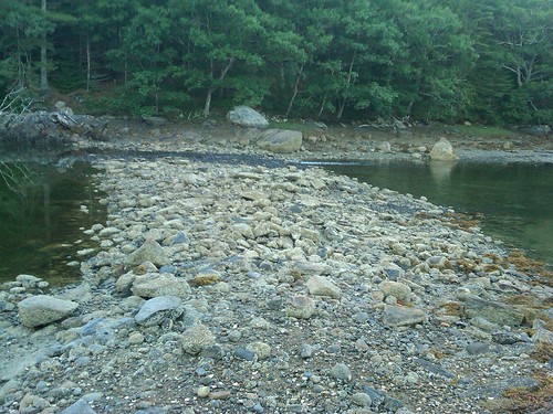
Part of the tidal barrage at the site of Heal's Lower Mill, Westport Island, Maine.


A nonprofit corporation, the Tide Mill Institute hopes to advance the appreciation of tide mill history and technology by encouraging research, by promoting appropriate re-uses of former tide mill sites and by fostering communication among tide mill enthusiasts.  The Institute's mission is:

  • to advance appreciation of the American and international heritage of tide mill technology;
  • to encourage research into the location and history of tide mill sites;
  • to serve as a repository for tide mill data for students, scholars, engineers and the general public and to support and expand the community of these tide mill stakeholders; and
  • to promote appropriate re-uses of old tide-mill sites and the development of the use of tides as an energy source.

Tide Mill Institute's 2015 symposium includes presentations on tide mills and tidal power by experts from France, Ireland, and the U.S.  Thomas McErlean will describe his experiences uncovering a nearly 1,400 year old tide mill at Nendrum, Northern Ireland, whose bed logs were cut in 619 AD.  The conference includes a low-tide field trip to view the site of the Friend's Mill, built about 1647-1649 on the Bass River in Beverly, Massachusetts, where a later foundation and some remains are still visible.  Concurrently, the Beverly Historical Society is opening its new exhibit on the Friend's Mill this weekend.

For more information or to register, contact Bud Warren at 207-373-1209 or email info@tidemillinstitute.org.

U.S. renewable energy share highest since 1930s

Tuesday, July 21, 2015

In 2014, about 9.8% of the total energy consumed in the U.S. came from renewable energy sources, according to the U.S. Energy Information Administration.  This represents the highest share of total domestic energy supply coming from renewable resources since the 1930s.

Prior to the growth of production and distribution networks for petroleum and other fossil fuels in the early 20th century, many homes used wood for heating as did industry.  This reliance on renewable biomass historically satisfied a significant portion of the total domestic energy demand.  But technological advances and the birth of the electric power industry led to greater use of other fuels.  As a result, the EIA reports that renewable resources' share of total domestic energy supply peaked in the 1930s, then declined.

But recent growth in U.S. renewable energy use has brought the country's energy mix back to nearly 10% renewable.  Indeed, from 2001 to 2014, renewable energy use grew an average of 5% per year, largely through increased use of wind, solar, and biofuels:
  • Wind energy grew from 70 trillion Btu in 2001 to more than 1,700 trillion Btu in 2014.
  • Solar energy (solar thermal and photovoltaic) grew from 64 trillion Btu to 427 trillion Btu.
  • The use of biomass for the production of biofuels grew from 253 trillion Btu to 2,068 trillion Btu.
According to EIA, inn 2014, slightly more than half of all renewable energy was used to generate electricity.  Renewable energy accounted for 13% of energy consumed within the electric power sector, the highest renewable use attributable to any sector.

Tidal power past, present, and future at Tide Mill Institute 2013

Thursday, November 14, 2013


The Tide Mill Institute held its ninth annual conference this past Friday and Saturday.  About 60 people interested in the past, present, and future of tidal energy gathered at the Topsfield Historical Society's Gould Barn in Massachusetts.  The audience included developers of recreated historic tide mills and modern tidal power projects, inventors of tidal turbine technology, academics, state legislators, historians, architects, and other enthusiasts of tidal power.

Tide Mill Institute's John Goff speaks about historic tide mills in Salem, Massachusetts.
Ocean Renewable Power Company's president and CEO, Chris Sauer, gave the keynote presentation on ORPC's efforts and success in developing modern hydrokinetic tidal power plants in the Gulf of Maine and elsewhere.  Chris described the research and development process that led to ORPC's Turbine Generator Unit or TGU.  He also described the engineering, regulatory, and commercial challenges of developing tidal power plants today, as well as ORPC's approach to overcoming these challenges.

Other presentations included: Professor Kerr Canning's exposition of a tide mill site he discovered on the Apple River in Nova Scotia; Professor Robert Gordon's look at tide mill mechanics at sites in York, Maine; a review of tide mill history on the Gowanus Canal in Brooklyn, New York, by Angela Kramer of the Brooklyn Historical Society and Proteus Gowanus; and a survey by representatives of local historical societies of tide mills on the North Shore of Massachusetts.

Tide Mill Institute members and attendees also enjoyed displays on historic and modern tide power projects, and informal discussions of archaeological discoveries and modern developments. 

The Tide Mill Institute will hold its 10th annual conference in 2014.

Tide Mill Institute to hold conference November 8-9, 2013

Wednesday, November 6, 2013

The Tide Mill Institute will hold its 9th annual conference this week in Topsfield, Massachusetts.  The event, to be held at the Topsfield Historical Society's Gould Barn on November 8 and 9, brings together people interested in the past, present, and future of tidal energy.

Tidal energy has been used to produce useful power since at least 619, based on archaeological finds at the site of Nendrum Monastery on an island off Northern Ireland.  Tide mills came to the New World along with early European settlers, who captured the energy embodied in the rise and fall of tides and put it to use powering grist mills, lumber mills, and other industries.  According to a 1979 paper, "Early Tide Mills: Some Problems", at one point over 300 tide mills operated in North America.  As their functionality was supplanted by steam engines, electricity, and internal combustion energy, much of society's historic use of tidal energy has been forgotten.

Meanwhile, people still look to the tides to provide useful power.  The Canadian province of Nova Scotia has been home to a 20 megawatt tidal power plant since 1984, and is promoting even more innovative uses of tidal energy resources through incentive programs and policies.  In the United States, the Ocean Renewable Power Company (ORPC) has developed the nation's first major grid-tied tidal electric generator, and has ambitious plans to bring more tidal and hydrokinetic projects online around the country.

This week's Tide Mill Institute event brings these themes together into a continuous narrative, from past through the present to the future.  The Tide Mill Institute's mission is:
  • to advance appreciation of the American and international heritage of tide mill technology;
  • to encourage research into the location and history of tide mill sites;
  • to serve as a repository for tide mill data for students, scholars, engineers and the general public and to support and expand the community of these tide mill stakeholders; and 
  • to promote appropriate re-uses of old tide-mill sites and the development of the use of tides as an energy source. 

The 2013 conference kicks off Friday night with an informal reception, followed by a symposium and dialogues Saturday from 8 AM through 3:30 PM.

For more information about the Tide Mill Institute, please contact:
  • Bud Warren - budw@myfairpoint.net 207-373-1209
  • Earl Taylor - ERMMWWT@aol.com 617-293-3052
  • Todd Griset - tgriset@preti.com 207-791-3000

Sunken history behind Penobscot dams

Monday, April 30, 2012

As two dams come out of Maine's Penobscot River, the conservation organization leading the dam removal effort has discovered what historians might view as sunken treasure: submerged mill dam structures from centuries past.  At the same time, these sunken dam remnants may continue to impede fish passage once the modern dams are removed, potentially frustrating the dam owner's intent in removing them.

The Penobscot River Restoration Trust is undertaking the removal of the Veazie and Great Works Dams on the Penobscot River.  Following a 2004 settlement agreement among previous dam owners, environmental and conservation groups, and governmental agencies, the Federal Energy Regulatory Commission approved their removal, along with the installation of fish passage equipment at the upstream Howland dam on the Piscataquis River.

Dam removal is expected to help fish and other aquatic wildlife, but FERC required the Trust to develop a plan to mitigate any adverse impacts of dam removal on infrastructure and archaeologic resources.  For example, the Trust knew that the historic remnants of previous dams and lumber mills lay submerged in the impoundment behind the Veazie Dam.  The remnants are associated with a series of lumber mills successively known as the Penobscot Mill Dam Company Mills, the City Mills, the Corporation Mills, and the Veazie Lumber Company Mill, which consisted of two sets of saw mills connected along water-control structures that ran parallel to the Penobscot River, and which were constructed in the mid-nineteenth century. Moreover, the site was purchased in 1889 for use as one of Maine’s first
hydroelectric facilities.

The Trust, along with the state historical preservation office, entered into a memorandum of agreement requiring the Trust to document the Veazie remnant structures after the modern dam is removed.  Because the historic mill dam is expected to impair natural river flow after the modern dam is gone, the Trust also plans to remove the historic structure after it is documented.

As it turns out, the historic Veazie dam is not the only historic or archaeological resource submerged beneath the Penobscot River's waters. While finalizing plans for removal of the Great Works dam, the Trust discovered that a similar, inundated, remnant structures exist in the Great Works impoundment.  The structural remains within the impoundment of the Great Works Dam were constructed as two structures in the early 19th century to provide water for two early sawmill complexes on the Penobscot River at Great Works: for the mills of Rufus Dwinel on the west bank, and for the mills of the Great Works Milling and Manufacturing Company on the east bank. These original dams, on each side of the river, were built as wing dams that extended upriver and out from the river bank, and likely were built independently of each other. The two dams were then consolidated under a single ownership in the early 1880s by the Penobscot Chemical Fibre Company, who built an early mill for producing wood pulp for paper on the Penobscot River.

Both of these sites may be eligible for nomination to the National Register of Historic Places as historic archaeological sites.

As a result of the re-discovery of these additional historic remnants, the Trust sought and obtained FERC's approval to document and remove part of the historic Great Works structures.  The Trust anticipates removing the modern Great Works dam as early as this summer.

December 28, 2010 - a history of heating my house, and current economics

Tuesday, December 28, 2010

In the wake of yesterday's blizzard, I've been thinking about how we heat our homes.  At over 150 years old, my house has kept people dry and warm for quite some time.  Much of the house remains the same as it was originally, while other "new" systems like electricity and running water have been installed later in the house's history.  Its heating systems have likely been changed several times in those years.

[Photo: down by the docks on Monhegan Island, Maine.  A large cache of propane tanks rests just out of view on the right.  Propane provides a major part of Monhegan's space heating energy needs.]

When the house was built, its residents likely burned wood to keep warm.  The front room or parlor on the first floor had a fireplace, as did the bedroom above the parlor.   (These fireplaces are now bricked up, as the chimney they used is now dedicated to an oil furnace situated in the basement.)  Until 1885, wood was the dominant fuel used to heat homes in the U.S.  After 1885, wood was surpassed by coal as the dominant heating fuel in the U.S.  It isn't clear whether my house was ever heated by coal.

Today, my house has three primary heating systems: an oil furnace in the basement that feeds warm air to the first floor, a propane "decorative appliance" in the kitchen, and small amounts of electric heat (a baseboard in one room, and a portable heater).  How much does it cost for me to operate these resources?  How are my decisions affected by that cost structure?  What should I do differently?

A few data points:

The portable electric heater is rated at 1,500 W.  In one hour, it uses 1.5 kWh.  One kWh = 3,412 Btu.  Thus in one hour of maximal operation, the heater puts out 5,118 Btu of heat.  Over the past several years, I've paid an average of 15.5 cents per kWh delivered.  This means the portable electric heater costs 23.25 cents per hour of operation -- or yields 146 Btu per penny.

According to the Maine Office of Energy Independence and Security, oil in Maine is retailing for an average price of $2.98 per gallon as of 12/20/2010.  In general, a gallon of heating oil contains about 138,690 Btu.  This divides out to 465 Btu per penny assuming 100% efficiency - or 386 Btu per penny at a more realistic 83% efficiency.

The Maine OEIS reports that the statewide average for propane based on a use of 925 gallons a year is $2.74 per gallon.  Notably, a gallon of propane contains less usable energy than does a gallon of oil; a gallon of propane might contain 91,330 Btu.  This divides out to 333 Btu per penny assuming 100% efficiency.  Even assuming 80% efficiency, this yields 266 Btu per penny.

Compare wood, a fuel the house is no longer set up to burn.  Wood can be an imprecise fuel type, with great variability in both how much wood is really in a delivered cord, as well as in how many Btu are available per cord.  (It's supposed to be 128 cubic feet per cord, but in practice air spaces mean there is almost never that much wood in a cord.)  The EIA recommends a figure of 20,000,000 Btu per cord.  Prices vary widely, but $200 per cord isn't a bad price in Maine.  Using that figure, you get 1000 Btu per penny assuming 100% efficiency, or 800 Btu per penny at a more reasonable 80% efficiency.  This makes wood seem like an attractive option.

Btu per penny may not be the only factor I consider in allocating my heating burden across these fuel sources.  For example, I can set the portable electric heater up anywhere in the house, while the oil-based warm air system is permanently installed in the first floor of the house.  Wood may appear economical, but without further capital investment (in a wood stove) is unavailable as a heating source.  Still, this look at the history of the house is illustrative.  What did previous owners spend on heating?  What fuels did they use?  Do we pay more today to heat our house than they did in 1860?  Are we more comfortable today than was the house's first owner?

July 9, 2010 - Smelt Hill Dam

Friday, July 9, 2010

A peek at part of the New Meadows quahog fleet:

New Meadows fleet

Today, I begin a look at Maine's first hydroelectric dam: the Smelt Hill dam on the Presumpscot River in Falmouth. Dammed in 1735 and with generating capacity installed in 1889, the Smelt Hill dam was the first hydro dam to be built in Maine.

In the early 1700s, the land around the Presumpscot River's mouth was owned by Thomas Westbrook, William Pepperell, and Samuel Waldo. Town records show that "a great dam" and sawmill were constructed on the lower falls in 1735. Resource conflicts began immediately, with upstream fish passage so impaired that Chief Polin, leader of the "Rockameecook" Tribe of Abenakis made the multi-day journey to Boston to ask Governor Shirley to require fish passage on all dams on the Presumpscot system. Accounts from the era describe “an acre of fish, mostly salmon” penned up below the impassable dam.

In 1726, George and Judith Knight settled on the Middle Road in Falmouth. Descendant Samuel Knight became known as the "Smelt King", famously claiming that if you laid his smelt catch end to end, it would reach all the way to Bangor. Perhaps thanks to his marketing pitches, the area came to be known as "Smelt Hill."

In 1889, the S.D. Warren Company erected a powerhouse (and new dam) at the site to supply electricity to its paper mill several miles upstream in Westbrook. The March 15, 1896 edition of the Electrical Journal gives a contemporary description of the power station:

The power plant of S. D. Warren & Co., at Smelt Hill, Maine, on the Presumpscot, has been started up for the first time. This plant was built some six years ago when the dam at the lower falls of the Presumpscot was constructed. The plant is arranged for twelve large turbine wheels. It has laid idle all this time, but recently the company has secured the right of way on the bank of the Presumpscot to Westbrook and has run a line of heavy copper wires whereon to convey the power from the new plant to the big paper mills. The distance is some five or six miles. The reason that this power has at last been transferred up the river and put into use is because of the lack of water at times to furnish sufficient power at the paper mills. They are now using only two of the turbine wheels at the Smelt Hill plant, but next week will use four of them.

It's interesting to see that even in the late 1800s, developers had a hard time getting easements to string transmission and distribution lines from distributed renewable resources to markets and loads.

By its end, Smelt Hill was the site of a 151-foot long, 31-foot wide and 15-foot high stone filled, timber crib dam, along with some associated structures. Smelt Hill Dam was not operational between 1943 and 1985. The Town of Falmouth's 2000 Comprehensive Plan documents the Smelt Hill dam as having been "damaged beyond repair in a 1996 flood." The 1996 flood -- almost 20 inches of rain in 3 days -- on the Presumpscot rendered the hydroelectric facilities and the fish lift at the dam inoperable and anadromous runs again ceased on the Presumpscot.

The dam was subsequently removed in October 2002. In a coming edition, I'll look at the issues that led to its removal.

Source note: much of the history of the area is drawn from the National Park Service's 1993 Historic American Engineering Report for the downstream Presumpscot Falls Bridge.


News: retired U.S. Navy Vice Adm. Dennis McGinn, vice chairman of the CNA Military Advisory Board, an retired-officer based energy and climate change think tank, visited Maine to call for greater energy independence.

July 1, 2010 - tidal power in the Basin

Thursday, July 1, 2010

Reporting from Boston today: this morning I attended a forum held at the British Consulate on energy and cleantech R&D opportunities, and had several good meetings to catch up with friends in the city. I'm always impressed by how much Boston has going on. Here's a peek out my office window here in Boston:

Boston skyline

Now, back to Maine, for a look at the tidal power history of the Basin, past and present.

Basin

The Basin is a nearly-completely enclosed bay in the town of Phippsburg, Maine. On a satellite photo map, you can see how the tide would ascend the New Meadows River (here, effectively a bay in the ocean) and then enter the narrow gates of the Basin between Brightwater and the Denny Reed Point area.

Last night I checked out the remains of a tide mill site at the upper end of the southeastern arm of the Basin. You can see where a stone structure was built across the mouth of the tidal flat. Last night, on a dropping tide, the water was flowing down over the stone structure, keeping a bed of mussels very happy.

Basin

I have found one source that says there were once two tide mills at this location. Other than the stone structure and evidence of old roads in the area, I didn't see much else in the way of obvious archeological clues. The mill pond is still relatively deep on the west side, and I did see small fish swimming around above the rock ramp. Black-backed and herring gulls were dropping shellfish onto the ledges to crack their shells, and several osprey passed overhead carrying their cleaned catches back to their nests.

Today, the Basin is protected by The Nature Conservancy. An anonymous donor left nearly 2,000 acres to TNC. Clam diggers still bring in a substantial harvest from the upper Basin (including the tide flats above the rock structure in the picture above), and it is a popular site for hiking, biking, and hunting.

June 17, 2010 - hay is for horses

Thursday, June 17, 2010

Yesterday, I looked at the U.S.'s historic energy usage.  In 1900, according to the U.S. Census, there were 76,094,000Americans, who consumed an estimated 9.587 quad of energy.  This works out to 125 million Btu per capita -- about 38% of today's U.S. per capita energy intensity.  As noted yesterday, I suspect this figure does not include the substantial energy that was used to feed draft livestock in 1900.  We don't usually think of livestock fodder as containing solar energy, but in a very real way, photosynthesis has been a major energy base for millennia.

To that end, I found an interesting note in the Thirty-Fifth Annual Report of the Secretary of the Maine Board of Agriculture, from 1892:

OUR HAY CROP.
By W. B. Kendall, Delivered at Clinton.

IMPORTANCE.

' On July 4th of each year our State of Maine celebrates its agricultural independence, by presenting its farmers with a constant, and never-failing million ton crop of grasses, the great basis of our agricultural life and wealth, in this northern clime.

So constantly do we gather this king of all crops into our barns, that, while almost every year, some of our cultivated crops, through drought, flood, insect blight or "season" are failures, the great hay crop, because ever present, is not given the gravity of consideration it demands. The hay crop of Maine has averaged, for the past ten years, one and one quarter million tons. At 87 per ton in the field $8,750,000 and at 810 per ton in the barn, $12,250,000,or more than the value of all others combined. We hear much of Maine's great lumber crop, and industry, but even this does not, in primal value, nor in the capital invested in its manufacture, nor in value after it is manufactured, amount to as much as the value of the hay crop in the field, the labor, machinery and barns for its storage and the cash value of the same delivered in Boston market, or consumed on the farm.

Our hay crop, the basis of our dairy industry, supports through our northern winters 1,100,000 head of cattle, horses and sheep.

In fact, a total failure of our hay crop for three years would practically depopulate our State, farm, town and city.

The agricultural report focuses on Maine's export of hay to southern New England, both to feed livestock used for food production (like the dairy farms) and to feed draft animals.  When you drive around the Maine countryside today, and see the hay fields that remain scattered here and there, it's easy to forget that all that hay is a vehicle for storing and consuming solar energy -- and that Maine has a long history of exporting that energy southward.

June 16, 2010 - a look into historic energy usage

Wednesday, June 16, 2010

The United States Energy Information Administration tells us that in 2008, Americans consumed 99.304 quadrillion Btu of "primary energy" resources.

How much is that? One quadrillion Btu, or "quad", is one thousand million million Btu, or 10^15 Btu. One quad is roughly the amount of energy contained in:
* 8,007,000,000 Gallons (US) of gasoline
* 293,071,000,000 Kilowatt-hours (kWh)
* 36,000,000 tons of coal
* 970,434,000,000 Cubic feet of natural gas
* 5,996,000,000 gallons of diesel oil
* 25,200,000 tons of oil

Dividing the 99.304 quads by the U.S. population, each American is responsible for 327 million Btu annually. Energy intensity, or the annual per capita consumption, peaked for America in 1978-1979 at 359 million Btu, but we've been moving back and forth above 311 million Btu since 1968.

How do these numbers compare to historic figures? US EIA has an interesting table showing estimated primary energy consumption for the U.S. for 1635-1945. The table shows 0.001 quad consumption in 1645, the first year for which data is provided. By 1835, the figure has broken above one quad (1.305 quad). Energy consumption grows fairly linearly through 1900 (9.587 quad), after which the figure shoots up sharply.

In 1835, the official U.S. population was 14.7 million. This gives an 1835 intensity of 88 million Btu -- about one quarter of today's per capita consumption.

Interestingly, I suspect these figures don't take into account the literal horsepower provided by livestock in 1835. How much more energy do we really consume today?

June 9, 2010 - tidal power in Maine: the Passamquoddy Power Project

Wednesday, June 9, 2010

Maine's historic wood and stone tide mills were just going dark in the 1930s. At the same time, larger tidal power projects were in the works. Chief of these was the Passamaquoddy Power Project, a large project designed to generate 300 to 500 MW of capacity.

In 1919, having returned from dam siting and building in South America, Dexter P. Cooper took some rest and relaxation on Campobello Island, just over the New Brunswick border from (and only accessible by road from) Lubec, Maine. As the August 1935 article in Popular Science put it:
With nothing to do, Cooper spent whole days watching the tides swirl past the island. He calculated the billions of horsepower going to waste. As a sort of hobby, he began imagining ways of putting the rising and falling water to work. In the end, he became convinced of the entire practicability of harnessing the Fundy tides.

What Cooper envisioned was the construction of five huge dams connecting various points and islands near the junction of Passamaquoddy Bay and Cobscook Bay. Cobscook Bay would be effectively walled off from Passamaquoddy Bay. As the Bay of Fundy's tide rose in Passamaquoddy Bay, the topography would make Passamaquoddy fill much faster than Cobscook. Once a five-foot head was built up, the penstocks would be opened and Passamaquoddy would fall down into Cobscook, spinning turbine generators along the way. Under expected conditions, the head could build up to as much as 18 to 23 feet. At low tide, gates would open and equalize the water levels.

Tidal projects have always had to deal with the effects of lunar time changes. Each night, the moon passes its zenith about 50 minutes later than the night before. In older times, this meant that the milling could only take place for part of the day, and not necessarily at convenient times. The Passamaquoddy project included an early pumped storage reservoir. A 180,000 horsepower pumping station at Haycock Harbor was to pump seawater into a 13,000 acre reservoir at 130' above sea level.

If you've ever been to Lubec, or if you follow tidal power projects, you probably know that the Passamaquoddy Power Project was never completed. I'm looking at the "why", to see what we can learn from history.

June 8, 2010 - tidal power in history: Winnegance to Passamaquoddy

Tuesday, June 8, 2010

I was fortunate to use wind power yesterday afternoon: I went sailing with a colleague on his Hunter 41. While on my way to the dock in Falmouth, I stopped by the site of a historic tide mill:
From Energy Policy Update
This isn't the best photo, but beyond the picnic table, you can see a stone pier extending across the mouth of Mill Creek. It seems information on the history of this mill site is limited, but it is suggested that it milled grain, and then lumber. The Town of Falmouth maintains a short but nice trail here, although parking is very limited.

In 1935, President Franklin Delano Roosevelt created the Federal Writers' Project, a program under the WPA designed to put writers to work while promoting economic development through tourism and industry. The project published 48 state guides to America (plus Alaska, Puerto Rico and Washington, D.C.) known as the American Guide Series. Each state in this series compiled its own detailed histories and descriptions of every city and town, along with narratives of interesting automobile tours.

Yesterday, I looked at the history of tidal power development at Winnegance, near Bath and Phippsburg, Maine. The 1937 Maine Writers' Project Guide describes the one remaining tide mill at Winnegance:

At 3 m. is the junction with a dirt road. Left on this road to a Tide Mill, 0.4 m., which until 1935 was used for cutting lumber. This old structure is a primitive forerunner of the mills and factories planned as part of the Passamquoddy Power Project.

So we can see that by 1937, policymakers including the federal government were reconsidering Maine's tidal power resources. Winnegance's tide mills were just on their way out, but the Passamaquoddy Power Project was just on the eastern horizon. Tomorrow I'll look at the 500 MW PPP in more depth.

June 7, 2010 - historic tidal energy: tide mills and

Monday, June 7, 2010

I've been looking into the history of tidal power and coastal use policy. The Winnegance story is illustrative of the kind of resources and opportunities that exist along the coast of Maine and many other states, as well as the kinds of conflicts that arise through development of these resources.

One classic conflict is between energy development and environmental protection. For dam proposals, whether tidal or in rivers, one of the common considerations is the impact on fish. Recently, this came up in the Fort Halifax dam case, where a lack of agreement over fish passage resulted in 2008 in the depowering and removal of the 1908 dam.

Fish protection came up with the dams and mills at Winnegance as early as 1892. In that year, the Supreme Judicial Court of Maine considered the case Oliver v. Bailey. On February 24, 1892, game wardens on patrol came across a bass net that had been strung across Winnegance Creek by John Oliver, whose property abutted the stream. This was prohibited by a special act passed in 1885, which regulated the level of water behind the dam as well as the catching of bass in Winnegance Creek.

The Court's opinion notes the the local history and alterations to land use based on commercial needs:

prior to 1837 Winnegance creek was an Inlet of the Kennebec river; that in that year, under the charter granted in 1835, the dam was erected across said creek, and northeast of the public highway, extending from the Bath to the Phippsburg shore; that sawmills on the dam were erected, and gates constructed, for the purpose of sawing lumber; and that the dam so erected, and the mills so constructed, thereon, had for their purpose the utilization of water to be held In the creek above said dam by the operation of said gates.

The Court's opinion provides an interesting look into how the tide mills played a major role in shaping the local landscape:
It was also agreed that since said date, at different times, as business might warrant, the several mills upon said dam have been in operation; that the owners of said mills each have above the same, and between the dam and the highway, booming privileges. In which to place their logs, and that the same were set off and allotted to the several owners of the mills on said dam, wherein each might place and hold his logs for use; that the flood gates in said dam are 18 feet wide, would admit scows, lighters, and rowboats, and that such had at times passed through said gates, and under said highway; that, at a certain time of tide, mastless scows, skiffs, and boats can pass under said highway, provided the owners of the booming privileges leave an opening so to do; and that there has been place left by the owners of said booming privileges for craft, of the kind and type designated, to pass up said creek.

The court again addressed the impacts of the tide mill development on navigation and commerce:
It was also agreed that the bridge connecting the city of Bath and the town of Phippsburg has been maintained by both for many years; that said bridge is built, legally, of cobwork spiling, and across the channel are stringers, affording a space under said bridge from 30 to 40 feet long, that gundolos may pass through up and down; that some 40 years ago a schooner was built and launched In the creek, and taken out to the Kennebec river, by removing a portion of the dam sufficient to give passage to said schooner from the creek Into the river; that the lighters mentioned, carrying boards and wood of some kind, have occasionally passed through the gates, and under the bridge; and that the millowners, when the tide had reached its flood, have all the gates so constructed that, at the beginning of slack water, they close, and the water is held for the purpose of running the mills constructed on said dam.

Oliver argued that the regulations were "intended only for the protection of salt-water fish, or fish that migrate between salt and fresh water". Oliver argued that the 1835 legislative dam authorization and 1837 dam construction, use of the upstream pond for booming logs, and limited navigation through the dam, "separated Wlnnegance creek above the dam from the general body of the tidal waters of the state, and taken it out of the above-cited statutes for the protection of migratory fish."

The Supreme Judicial Court disagreed, stating, "The statutory protection of these fish is as important now as before the erection of the dam." Oliver lost his case, and presumably his net.

In Oliver's case, the court wrestled with the question of whether the tidal power development had so fundamentally changed the landscape as to take Winnegance Creek from tidal to non-tidal status. The court concluded that, in light of environmental considerations, it had not. There may have been other more subtle issues in play in the 1892 case, but it provides an interesting window into the past history of tidal energy development in Maine.

I'm curious how this issue would be addressed today. What are the inshore effects of tidal barrage and related power technologies? Today these issues might not come up in the context of game wardens, but the descriptions of the tide mills' impacts of navigation, commerce, and fisheries all have relevance to modern tidal power development.

Soon to come: more Winnegance history, and a look at how things were for the much larger Passamaquoddy Power Project in the 1930s.

June 4, 2010 - tidal power in Maine, a history, part 1

Friday, June 4, 2010

Humans have harnessed the mechanical energy of tidal fluctuations for a long time -- at least as far back as the Romans in 600 A.D., and possibly as early as 200 A.D. The exact mechanisms vary, but the basic idea is to convert the potential energy of water that has been lifted by a high tide as it falls to a lower elevation. Typical sites are on tidal estuaries or rivers: sheltered from the effects of open ocean waves, but salty enough to have a significant tide.

Tide mills were common in Maine, especially just downriver from my house in Bath. At Winnegance, on the Bath-Phippsburg line, a bend in the Kennebec River with a natural cove made for optimal conditions for tidal power.

The History of Phipsburg, Maine, from George Varney's 1886 A Gazetteer of the State of Maine, describes some of the local resources:

At the north looms Parker’s Head, and at its south-western side is the inlet basin forming the tide-power known as Parker’s Head Mill Pond. Next succeed the harbor at Phipsburg Center, with Drummore Bay two miles above, with inlet and tide-power. Through Fiddler’s Reach, a curve of the Kennebec around the northern end of Phipsburg, we pass to Winnegance Creek, nearly three miles in length, and a basin at its extremity, forming two unsurpassed tide-powers, and separating Phipsburg from Bath and from West Bath except for a neck 200 rods in width, the Winnegance Carrying Place.

The History gives more detail on the Winnegance mills:

On the Winnegance Tide-Power, three miles from Bath post-office, and four miles from Phipsburg Center Village, have been sixteen mills, nine on the Bath side and seven on the Phipsburg side of the line. Some of these, however, were burned several years since. There are now ten sawmills and one grist-mill operating in the town.


So why Winnegance? The site was right, in that the coves and tide range were ideal. Furthermore, the site was near the mouth of the Kennebec River, where millions of logs floated downriver every spring and summer for processing into lumber, and loading onto schooners to send the boards to markets around the world. Many of the older houses in the Winnegance and Bath area, ours included, bear the marks of the kind of up-and-down tide-powered saws that operated there.

I'm curious to learn more about why tide mills largely vanished. (At Winnegance, the Morse & Sons Lumber mill still operates where the Morses have run it since 1801, but it no longer apparently harnesses the tides.) An interesting piece in Discover Maine Magazine points to the inconvenience of the timing of tidal power. If you are limited to tapping the ebb flow, the time of the peak drop will move -- at Winnegance, each high tide is 12 hours, 22 minutes later than the previous -- so some days, your power resource will only really be operative at night. I'm not sure this was enough to eliminate most of the tidal power development in Maine, but it was a start.

I'm also going to look at more ambitious historic tidal power plans like the Passamaquoddy Power Project.

June 3, 2010 - Red Sox, whales, and tidal power projects in history

Thursday, June 3, 2010

I'm fortunate to be headed to this afternoon's Red Sox game. Boston is not really that far from Maine, at least not by Maine standards. I grew up around Boston. Between business and family, I'm often in Boston these days. To be able to take in a Sox game is a real treat.

Last weekend, I went on a whale watch out of Boston with the New England Aquarium. We saw a number of humpback and minke whales, plus an offshore seal that may have been a gray seal.

We cruised through Boston Harbor, with views of the Custom House and the working waterfront. We passed right by the Everett LNG terminal and the short but prominent wind turbine. Past the archipelago of Boston Harbor Islands National Park, we headed off to Stellwagen Bank, where the action was.

I go on whale watches mostly to see the marine mammals, birds and fish. I've had some amazing encounters out there.

Sailing from different ports from Key West through Essipit in the Cote-Nord of Quebec, it's interesting to see common threads of history in harbor and coastline development. One of these that I've encountered in several places recently is historic tidal power development.

Tomorrow, I'll look into a local tide mill just downriver from my house, as well as the grander Passamaquoddy Power Project of the 1930s: a proposed 500 MW international tidal barrage project. The lessons we can learn from history are invaluable as we consider new iterations of old questions.