I've just returned from a visit to one of Maine's offshore islands. Life on a small island can seem fundamentally different: the pace of life is driven by the tides and boat schedules, and fog can often replace the mainland's heat. It was a good place to think about energy policy, and history, and where we can go from here.
More updates to follow regularly.
Brief news recap:
Friends of Merrymeeting Bay (FOMB) have provided 60-day notice of intent to sue the owners of four Maine dams under the Clean Water Act over issues relating to Atlantic salmon. FOMB have a history of legal activism over fish (including eel) passage at dams in Maine, particularly in the Merrymeeting Bay watershed. If you've read my earlier posts about kayaking in Merrymeeting Bay, you might know that Merrymeeting Bay is where the Androscoggin River flows into the Kennebec. FOMB has identified four dams in its threat: the Lockwood Dam in Waterville, "Hydro Kennebec" in Winslow, Shawmut Dam in Fairfield and Weston Dam in Skowhegan.

Energy powers society; society's choices shape energy policy. A blog about our energy resources and the choices they present for society.
Showing posts with label Merrymeeting Bay. Show all posts
Showing posts with label Merrymeeting Bay. Show all posts

June 25, 2010 - abandoned bridges, and paddling Merrymeeting Bay
Friday, June 25, 2010
Tidal thoughts today, following yesterday's E2Tech forum on ocean energy. E2Tech put on a great event, with speakers Beth Nagusky from state government, Des Fitzgerald of Principle Power, John Ferland of Ocean Renewable Power Company, and Bill Staby of Resolute Marine Energy. Thus all on one panel, we had developers of wind, tidal, and wave energy projects, plus a representative from the government.
Paddling back through time around the site of the former Merrymeeting Bay Bridge.

The Merrymeeting Bay Bridge was built in 1835 to connect Topsham with East Brunswick. Located near where the Androscoggin River flows into the Bay, the bridge provided a shortcut for commerce. Friends of Merrymeeting Bay have a great history page about the bridge. Bottom line: tolls barely exceeded maintenance costs, and the bridge was repeatedly and badly damaged by floods and ice. In 1896, the bridge was finally wiped out by the spring freshet, and was not rebuilt.
Today, you can still see the granite cribbing that was used to support the 24' wide wooden deck. Here's a shot of the stonework on the south side of Mustard Island:

And on the north side:
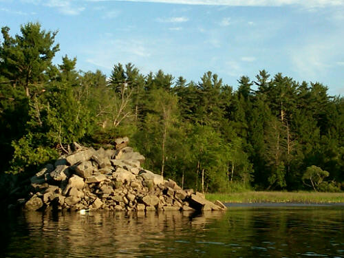
Right near this point, a very large fish (probably a striper or pike) roiled the water next to my boat, making a 48" diameter boil on the surface. Sturgeon were slapping down all around, and I flushed a great blue heron. There was also a splashy beaver.

I'm interested in learning more about how it was decided to build the Bay Bridge back in the 1830s, and what it was like to spend an estimated $1 million in maintenance over 60 years on an asset that just barely broke even in a good year. I'll do some research, but I will be sure to return to the Bay for another firsthand look.

Paddling back through time around the site of the former Merrymeeting Bay Bridge.
The Merrymeeting Bay Bridge was built in 1835 to connect Topsham with East Brunswick. Located near where the Androscoggin River flows into the Bay, the bridge provided a shortcut for commerce. Friends of Merrymeeting Bay have a great history page about the bridge. Bottom line: tolls barely exceeded maintenance costs, and the bridge was repeatedly and badly damaged by floods and ice. In 1896, the bridge was finally wiped out by the spring freshet, and was not rebuilt.
Today, you can still see the granite cribbing that was used to support the 24' wide wooden deck. Here's a shot of the stonework on the south side of Mustard Island:
And on the north side:
Right near this point, a very large fish (probably a striper or pike) roiled the water next to my boat, making a 48" diameter boil on the surface. Sturgeon were slapping down all around, and I flushed a great blue heron. There was also a splashy beaver.
I'm interested in learning more about how it was decided to build the Bay Bridge back in the 1830s, and what it was like to spend an estimated $1 million in maintenance over 60 years on an asset that just barely broke even in a good year. I'll do some research, but I will be sure to return to the Bay for another firsthand look.
Subscribe to:
Posts (Atom)
